A Complete Guide to Mesoscale Convective Systems: How They Form, Cause Flooding, and Trigger Power Outages
- What Is a Mesoscale Convective System?
- Is a Mesoscale Convective System Larger Than a Regular Thunderstorm?
- How Do Mesoscale Convective Systems Cause Flooding and Other Hazards?
- How to Tell If It Is a Mesoscale Convective System on Radar
- How Should You Prepare Before Mesoscale Convective Systems Arrive?
- Stay Powered and Prepared When Severe Weather Moves In
- FAQs
A mesoscale convective system can turn a warm U.S. summer evening into hours of heavy rain, dangerous wind, flooded streets, and power loss. These organized storm clusters matter because they cover large areas, last for hours, and often arrive after dark. Learning the signs helps you protect your home, charge essentials, and prepare for an outage before the worst conditions reach your neighborhood.
What Is a Mesoscale Convective System?
A mesoscale convective system is a large, organized group of thunderstorms that behaves as one larger weather system. Individual storm cells inside it may strengthen, weaken, merge, or fade, while the overall system continues moving and producing hazardous weather across a broad area.
“Mesoscale” describes a storm system that is larger than a single thunderstorm but smaller than a large regional weather pattern. Some MCS events can spread across an entire state and last over 12 hours, which helps explain their potential to affect multiple towns, highways, and utility networks during one event.
How Do Mesoscale Convective Systems Form?
They need fuel, lift, and organization. Warm, humid air near the ground provides storm energy, while fronts, drylines, outflow boundaries, and upper-level disturbances help lift that air into the atmosphere. Wind changes with height, then helps storms organize into a longer-lasting system.
The self-sustaining process often starts near the ground. Heavy rain cools the air below the storm. That cooler air sinks, reaches the surface, and spreads outward as a gust front. As it moves, it lifts warm, moist air ahead of the system. New thunderstorms can then develop along that boundary and join the existing storm area.
Cold pools play an important role in this process because stronger rain-cooled air near the surface can help smaller storms grow upscale into a larger MCS when the surrounding wind pattern supports organization.
Many warm-season systems in the central U.S. strengthen during the evening or overnight. That timing adds risk because people may be asleep when rain, wind, and outages intensify.
Is a Mesoscale Convective System Larger Than a Regular Thunderstorm?
Yes. A regular thunderstorm may affect one town or one part of a county. A mesoscale convective system can cover multiple counties, a metro area, or a large portion of a state. It can also continue for hours as older cells weaken and new ones form.
Because an organized MCS can last for a long period, it may deliver repeated heavy rain, frequent lightning, and strong winds over a wide footprint. A short pop-up thunderstorm may pass with a burst of rain. A larger storm complex can affect road travel, power lines, basements, sump pumps, cell service, and refrigerators during the same event.
Feature | Regular Thunderstorm | Mesoscale Convective System |
Typical scale | Local | Regional |
Duration | Often brief | Several hours, sometimes overnight |
Radar look | One cell or small cluster | Line, bow, or broad storm complex |
Main concern | Local rain, lightning, wind | Flooding, damaging wind, outages |
Home planning need | Short-term caution | Storm and power readiness |
When a storm complex is large, organized, and still rebuilding, the impact can continue long after the first round of thunder passes.
How Do Mesoscale Convective Systems Cause Flooding and Other Hazards?
Flooding develops when heavy rain falls fast, covers a broad area, or repeats over the same location. Mesoscale convective systems can create all three conditions, especially during the warm season across the central and eastern U.S.
Rapid Flooding Risks
A large storm complex can produce intense rainfall across a wide region for several hours. When new storm cells repeatedly move over the same roads, creeks, and neighborhoods, water levels can rise quickly.
This “training” pattern can overwhelm storm drains, low-water crossings, small streams, and already saturated soil. Urban areas face added risk because pavement and concrete reduce ground absorption. Even a blocked drain or low intersection can become hazardous before major rivers begin flooding.
Warm-season MCS events are closely linked with flooding across the central and eastern United States because they often combine large rain coverage with high rainfall intensity.
Other Severe Weather Threats
Heavy rain is only part of the danger. A strong MCS can also bring:
Straight-line winds that snap branches, topple trees, and damage roofs
Frequent lightning that creates dangerous outdoor conditions
Hail inside stronger embedded storm cells
Brief tornadoes in some storm-line setups
Power outages caused by wind damage, lightning strikes, falling trees, and flooded electrical equipment
High winds, lightning, and falling debris can damage local power infrastructure and leave neighborhoods without electricity for hours or longer.
How to Tell If It Is a Mesoscale Convective System on Radar
A few radar patterns can help you spot a possible mesoscale convective system before conditions worsen. Look for a large, organized area of storms with connected heavy returns across a wide region. In many weather apps, the strongest parts may show up as red, orange, or purple.
A long, advancing line can point to a squall line. A curved or bowing segment may suggest stronger wind potential. A wide cluster with new storms forming on one side can signal heavy rain risk, especially if the same communities stay under storms for a long period.
Movement matters as much as color. If new cells keep forming upstream and sliding across your area, the flooding risk rises. If the leading edge accelerates and bows outward, damaging wind may become the bigger concern.
Radar can support your judgment, but alerts should guide action. Severe thunderstorm warnings, flash flood warnings, and tornado warnings are issued for immediate hazards. If your area is included, move to safety, avoid flooded roads, and keep phones charged for updates.
How Should You Prepare Before Mesoscale Convective Systems Arrive?
Overnight outages are common during major MCS events. Phones lose battery, roads flood quickly, and visibility drops fast during heavy rain. A basic emergency plan helps households stay organized when conditions worsen.
Build a Basic Storm Readiness Kit
Keep essential supplies in one known location. A practical U.S. household kit should include:
Drinking water and shelf-stable food
Flashlights or LED lanterns
A battery-powered or hand-cranked radio
First-aid supplies and necessary medications
Pet and baby supplies, if needed
Waterproof storage for key documents
Work gloves for light cleanup
A printed list of family contacts
Before storms arrive, bring in patio furniture, trash bins, umbrellas, toys, and loose yard items. Clear visible debris from gutters and drains if conditions are still safe. Charge phones, laptops, battery packs, rechargeable lights, and weather radios.
Prepare for Power Outages Before the Storm Hits
Power planning should focus on essentials first. Make a short list of devices that matter most during an outage:
Phones for alerts and family contact
Lighting for safe movement at night
Router or hotspot, if service remains active
Refrigerator or mini fridge for food and medicine
Check wattage before connecting devices to any backup source. Refrigerators, pumps, and some medical devices may need extra starting power. Battery capacity also matters because runtime changes with device load, temperature, and usage habits.
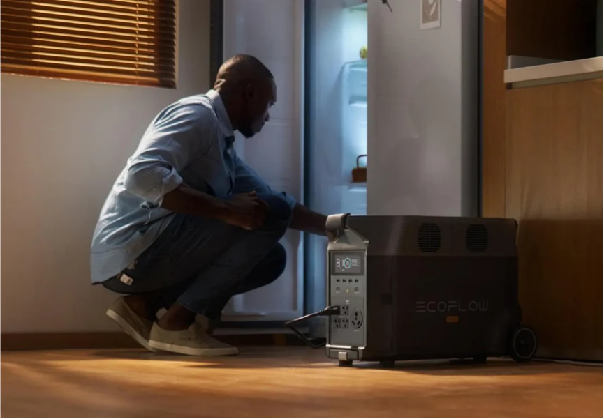
Where Portable Power Stations Fit Into MCS Preparedness
A portable power station can help keep essential devices running during a storm-related outage. The EcoFlow DELTA Pro Portable Power Station is designed for home backup and emergency preparedness, with a 3.6kWh base capacity, 3600W AC output, and expandable storage for longer outages. Its LFP battery chemistry is also built for long cycle life, which can be useful for households preparing for repeated severe-weather events.
During a mesoscale convective system, backup power often goes toward practical needs first. That may include charging phones, powering LED lights, running a router, keeping a fan on during humid summer nights, or helping a refrigerator maintain food temperature during a prolonged outage.
Place the power station indoors, away from water, and keep it charged before storm season begins. If solar panels are part of your setup, test the full system on a calm day so cable placement, charging speed, and operation are already familiar before severe weather arrives.
Stay Powered and Prepared When Severe Weather Moves In
A mesoscale convective system can bring hours of rain, wind, lightning, flooding, and power loss across a wide area. Understanding how it forms, how it appears on radar, and how it affects homes gives you time to act. Watch alerts, protect your property, avoid flooded roads, and keep essential power ready. A charged portable power station and a clear family plan can make a difficult night safer and easier to manage.
FAQs
Q1. Can Mesoscale Convective Systems Happen Outside Summer?
Yes. Mesoscale convective systems are most common during the warm season, especially from late spring through summer, but they can also develop during early fall or even winter in some regions. Cooler-season events usually depend on strong atmospheric dynamics and Gulf moisture, particularly across the southern and central United States.
Q2. Can a Mesoscale Convective System Develop Without Tornadoes?
Yes. Many MCS events never produce tornadoes. The most common hazards are heavy rainfall, straight-line winds, lightning, and flash flooding. Some storm lines create damaging wind gusts comparable to weak tornado damage, even when no tornado warning is issued during the event.
Q3. How Fast Can a Mesoscale Convective System Move?
Movement speed varies widely. Some systems move under 20 mph and create prolonged flooding concerns, while others travel over 50 mph and produce widespread wind damage across several states in one night. Faster-moving systems often increase the risk of downed trees, power-line damage, and dangerous travel conditions.
Q4. Can Portable Power Stations Run Refrigerators During Severe Weather Outages?
Yes, many portable power stations can support refrigerators during short-term outages if the battery capacity and output are large enough. Runtime depends on refrigerator size, starting wattage, ambient temperature, and how often the door is opened. Higher-capacity systems like the EcoFlow DELTA Pro are better suited for extended outage scenarios and essential home backup use.
Q5. Why Do Mesoscale Convective Systems Often Strengthen at Night?
Nighttime strengthening is closely tied to low-level moisture transport and atmospheric wind patterns. In the central U.S., warm and humid air can continue feeding storms after sunset, allowing thunderstorm clusters to remain active for hours overnight. This pattern is one reason many major flooding and overnight outage events occur while people are asleep.
Disclaimer: This article is for informational purposes only and does not constitute professional weather, emergency management, electrical, or safety advice. Mesoscale convective systems, flash flooding, and severe thunderstorm conditions can develop rapidly and vary by region, terrain, and infrastructure. Always follow local emergency alerts, evacuation instructions, and severe weather guidance during hazardous conditions. For official safety and weather preparedness information, please refer to National Weather Service Severe Thunderstorm Safety Rules, NOAA Severe Weather 101: Mesoscale Convective Systems, Ready.gov Floods, and Ready.gov Build A Kit.
For press requests or interview opportunities, reach out to our media team
media.na@ecoflow.com