An In-Depth Guide to High and Low Pressure Systems
- About Pressure Systems
- What is a High Pressure System
- What Type of Weather is Associated with High Pressure Systems
- What is a Low Pressure System
- What Type of Weather is Associated with Low Pressure Systems
- What Should I Care About Low Pressure Systems in Winter
- But We Can Be More Resilient Than Ever
- Weathering the Storm with Confidence
- FAQs
Atmospheric pressure shapes our reality. The weight of the air drives winds and dictates whether skies remain clear or unleash chaotic storms. These invisible forces determine our safety and comfort during the changing seasons. Understanding the mechanics behind the atmosphere allows for better preparation against volatile weather. We will explore the science of pressure, analyze specific winter threats, and examine how the systems impact our daily lives.
About Pressure Systems
We exist at the bottom of a vast ocean of gas. Gravity pulls air molecules toward the surface to create a force known as atmospheric pressure. The sun heats the planet unevenly. The equator absorbs immense energy. Air warms, expands, and rises in those regions. Scientists label areas where air leaves the surface as low pressure systems. Conversely, the poles remain cold. Dense air sinks toward the ground to pile up in mounds of mass called high pressure systems. Nature seeks equilibrium constantly. Air rushes from the surplus of the high pressure to fill the void of the low pressure. We perceive the movement as wind. Rotation of the Earth spins these winds into giant spirals. These spinning giants act as the engines of our climate. They transport heat and moisture across the continents.
What is a High Pressure System
Meteorologists refer to a high pressure system as an anticyclone. A blue "H" marks the center on a weather map. Air in the systems sinks from the upper atmosphere toward the ground. High pressure systems are characterized by sinking air that warms up and dries out. Physics dictates that compressing a gas increases its temperature. The sinking motion prevents air from rising. The lack of upward movement stops clouds from forming. Winds spiraling out from the center turn clockwise in the Northern Hemisphere due to the rotation of the Earth. The air becomes heavy and dense. It pushes down on the surface with significant force. Such systems often act as a wall in the atmosphere. They block approaching storms and force weather patterns to move around the periphery.
What Type of Weather is Associated with High Pressure Systems
Sinking air acts like a heavy blanket that suppresses cloud formation. High pressure system weather creates specific conditions:
Clear Skies: The downward force of the air prevents water vapor from rising and condensing. The result is typically a bright blue canvas overhead with zero cloud cover.
Temperature Extremes: The lack of clouds creates volatility. The sun strikes the ground with full intensity during the day. Heat radiates into space rapidly at night.
Heat Domes: Strong systems can stall over a region in summer. They trap warm air near the surface like a lid on a pot. Temperatures build day after day to dangerous levels.
Arctic Cold: Winter highs originate in polar regions. Dense and freezing air slides south. It brings the lowest temperatures of the year and biting wind chills.
Fog and Stagnation: Calm winds fail to mix the atmosphere. Pollutants and moisture become trapped near the ground. Dense fog or smog can form and linger for days.
What is a Low Pressure System
Imagine a giant atmospheric vacuum cleaner. A red "L" signifies these areas on a map. Air converges at the surface and rushes inward to fill the deficit. Low pressure systems are characterized by rising air and instability. With nowhere else to go, the converging air ascends into the upper atmosphere. It encounters lower pressure and expands. Expanding gas cools down rapidly. Cold air holds less moisture than warm air. Water vapor condenses into droplets to form clouds. The rotation of the Earth deflects the winds rushing inward. The result is a counter-clockwise rotation in the Northern Hemisphere. These cyclones serve as the primary engines for active weather across the globe.
What Type of Weather is Associated with Low Pressure Systems
Rising air cools and condenses water vapor into precipitation. Low pressure system weather drives the following conditions:
Cloudy Overcast: The upward motion of air facilitates constant cloud development. Grey skies become the norm as the system approaches.
Precipitation: The atmosphere unloads moisture as rain or snow. The type depends on the temperature profile of the air column.
High Winds: Air moves rapidly to cross the gradient between high and low pressure. A deeper drop in pressure creates a steeper gradient and more powerful gusts.
Volatile Fronts: Distinct air masses collide. Warm fronts produce steady rain and fog. Cold fronts trigger violent thunderstorms or sharp temperature drops.
Winter Chaos: These systems wrap Gulf moisture around cold air. The combination produces heavy snow bands, sleet, and freezing rain.
What Should I Care About Low Pressure Systems in Winter
Winter cyclones pose a unique threat to infrastructure and life. Cold air transforms manageable rain into destructive ice and snow. Three specific storm tracks frequently batter North America.
The Texas Low
A dip in the jet stream often digs deep into the southern plains. It allows cold air from the Rockies to spill south. Simultaneously, warm and humid air streams north from the Gulf of Mexico. The collision point is frequently over Texas. These systems gather strength and track northeast. They tap into the energy of the warm ocean water. When the moisture rides over sub-freezing air sitting across the American midsection, the result is often a devastating ice storm. Freezing rain coats power lines and trees. The weight snaps cables and causes widespread grid failure. The February 2021 event serves as a stark reminder. Millions lost heat for days when the grid collapsed under the strain.
The Colorado Low
Winds blowing from the Pacific Ocean cross the Rocky Mountains. The column of air stretches vertically as it descends the eastern slope. Physics dictates that the column must spin faster as it stretches. A low pressure center spins up over eastern Colorado. These systems usually track northeast toward the Great Lakes. They draw warm air from the south and wrap it around the northern side of the low. Here, the air meets the arctic cold sector. The result is a "comma head" of heavy snow and high winds. The flat terrain of the plains offers no friction to slow the wind. Gusts create whiteout conditions that bury roads and isolate communities.

The Nor'easter
The Nor'easter reigns as the most powerful type of winter storm on the East Coast. These cyclones form within 100 miles of the Atlantic shoreline. They thrive on the temperature difference between the freezing continent and the warm waters of the Gulf Stream. The ocean provides high-octane fuel in the form of heat and moisture. A blocking high pressure system over the ocean can pin the storm against the coast. They bring heavy snow inland and hurricane-force winds along the shore. Meteorologists watch for "bombogenesis" with these storms. The term describes a pressure drop of at least 24 millibars in 24 hours. Such a rapid intensification effectively causes the storm to explode in power.
The common thread among these storms is the ability to destroy the power grid. Heavy wet snow from a Colorado Low or ice from a Texas Low can snap transmission lines in seconds. When the grid fails in winter, a home becomes a refrigerator. Modern heating systems depend on electricity. Even gas furnaces require power to run fans and ignition circuits. Losing heat during a deep freeze is a life-threatening emergency.
But We Can Be More Resilient Than Ever
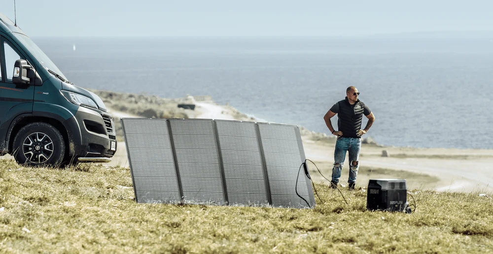
Preparation is the only defense. In the past, noisy gas generators offered the only solution. They required outdoor operation and fresh fuel storage. Today, battery technology provides a silent and indoor-safe alternative. The EcoFlow DELTA Pro Portable Power Station is reflective of a significant leap in home backup.
Safety remains the primary advantage of the DELTA Pro. It utilizes a Lithium Iron Phosphate (LFP) battery. The chemistry is stable and long-lasting. It supports years of regular use without significant degradation. Unlike gas generators, the unit emits no fumes. A family can operate it safely in a living room or bedroom. The unit delivers a massive 3600W of AC output. Such power can handle 99% of household devices, including space heaters and electric blankets. The surge capacity extends even higher to start heavy motors.
Capacity is critical during a long outage. The base capacity of 3.6kWh is expandable. You can connect extra batteries to reach up to 25kWh. Such scalability allows a homeowner to tailor the system to their specific needs. The DELTA Pro is engineered for resilience. It can discharge power in temperatures as low as 14°F (-10°C). Vital lifelines remain active even if the unit sits in a chilly garage. Recharging occurs quickly when the grid returns briefly. You can also connect solar panels to harvest energy from the sun. The system becomes a self-sustaining power plant.
Possessing a reliable home battery backup changes the nature of a disaster. A winter storm transforms from a crisis into a manageable event.
Weathering the Storm with Confidence
Pressure systems serve as the architects of our climate. High pressure brings clear skies and temperature extremes. Low pressure generates the storms that challenge our infrastructure. Winter cyclones like the Texas Low or Nor'easter carry significant risks for power stability. Understanding the mechanisms allows us to prepare effectively. Tools like a reliable battery backup turn a potential disaster into a minor inconvenience.
FAQs
Q1: Does high pressure always mean clear and sunny skies?
No. We generally associate high pressure with sunshine. However, winter systems can trap moisture near the ground. Meteorologists call the condition anticyclonic gloom. A thick layer of fog or low clouds might persist for days because the sun lacks the power to burn off the moisture. Drivers should be careful, as visibility can drop significantly during these stagnant periods.
Q2: Can weather patterns affect my blood pressure?
Yes. High pressure systems often bring cold air in winter. Low temperatures cause your blood vessels to constrict. Your heart has to work harder to circulate blood. Studies show that blood pressure readings tend to rise during cold snaps. People with heart conditions should stay warm and monitor their health when the barometer rises.
Q3: Why does the air quality often get bad during calm weather?
High pressure acts like a lid on the atmosphere. The sinking air traps pollutants close to the surface. Smoke and exhaust cannot rise and disperse. We refer to the situation as a temperature inversion. You might notice a haze over the city. It becomes important to limit outdoor exercise if you suffer from asthma or other respiratory issues.
Q4: What does a ring around the moon mean?
A halo around the moon is a reliable signal that a low pressure system is approaching. The ring forms when light passes through thin ice crystal clouds. These clouds arrive ahead of a warm front. You can generally expect precipitation to start within twenty-four hours. Use the sign as a warning to prepare for rain or snow.
Q5: Why do I hear distant sounds better before a storm?
A low pressure system often puts a layer of clouds over your head. That layer can bounce sound waves back toward the ground. The air also holds more moisture. Sound travels very efficiently through humid air. Hearing a distant train or highway noise clearly is often a clue that the weather is about to turn bad.
For press requests or interview opportunities, reach out to our media team
media.na@ecoflow.com